O Kornatima
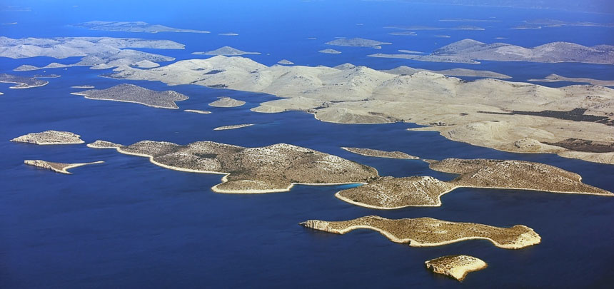
The Kornat Islands are the densest archipelago in the Mediterranean. Nowhere else in this large sea is such a great number of islands crammed in so little space. Because of ambiguous criteria of the definition of an island in general, there is no general agreement about their number. But we think that we shall not err much if we determine their number at 150. The area pf the sea in which they are located is about 320 square kilometres.
The largest island of the archipelago is Kornat. The inhabitants of the island of Murter, the most numerous of the owners, refer to it as Kurnat, to the archipelago as Kurnati, and to themselves as Kurnatari, other neighbours and the wider public refer to them as Kornat and Kornatari respectively. The island has an area of 32 525 315 square metres; it's shoreline is 66,1 km long, and it is 235 m high - the peak Metlina. The island is 25,2 km or 13,6 nautical miles long. But the special feature and identifiability of the Kornat Islands are the islets.
Like many other shepherds and farm labourers, people working in the Kornat Islands obtained pastures and later cultivable land by burning. The process was repeated after several years , in a specific order and at a specified time. Although it is known that events sometimes went out of control, on the whole the pasture was burnt in an organized way. The consequence of burning pastures is the almost lunar landscape of the island of Kornat and some of the larger islands, e.g. Kurba, Škuj, Lunga.
The Dry Walls
Of all the artefacts that the Kornat hand had created the most important and most impressive is certainly the wall or, more precisely, the dry wall. One of the basic features of the dry walls is their orientation. Since all large islands are elongated, all the walls are built from sea to sea, i.e. from one side of the island to the other. The wall is exactly as high as it is necessary to prevent sheep jumping over it and crossing to someone else's pasture. It is exactly as wide as it is necessary to prevent the force of the wind to break it.
Another artefact in the Kornat karst attracts equal attention as the dry walls: isolated enclousers - olive groves surrounded with the dry walls. We find them in more than a hundred places in the archipelago, at "most unexpected" locations at that. On the steep sides of Škuj and Smokica, on the saddles of Smokvena and Gustac, on the gentle slopes of Njivica, Piškera, Žakan, Lavsa, Suha Punta, Statival, Pinezel, and Grba, on the level plateaus from Knježak to Šipnate.
National park Kornati
Part of the archipelago, roughly two thirds of the land and the sea, is a national park today. The islands of Žut and Sita and their islets are omitted from the Act introducing the highest level of protection, although they belong to the Kornat group - geomorphologically, geographically and culturally. After the creation of the national park in 1980, many scholarly investigatons have taken place there, particularly those as refer to the natural heritage. The studies have brought to light much information about the geological, meteorological, geographic, biologic and other distinctive characteristics of the Islands. Up to the present, they have identified 537 species of invertebrates, 160 species of fishes, one tortoise and three species of mammals, one of which - the monk seal - is probably extinct.
In spite of such large numbers, all agree that the Kornat Islands have not been investigated sufficiently. This statement can be substantiated by a single fact: scholars think that the numbers of living organisms in the sea, if they were studied, could be between 2500 and 3000. In the same way, the anthropological heritage of the islands has not been investigated or described sufficiently.
Catering facilities in the park offer basic services to the visitors; the park also has a service for surveillance and monitoring visitor behaviour, information and reception centres. The visitors are allowed to go anywhere in the park except in the area around Purara island and the cliffs Mala Purara and Violić which were declared areas of special protection. Visitors of the National Park "Kornati" must always acknowledge and respect the fact that all islands of the Kornati archipelago, apart from being protected as natural heritage, are also private property.
There are eight cleared up and marked hiking trails in the area of the National Park "Kornati" and they lead to the lookouts from which it is possible to sea the Kornati archipelago in its entirety, or some of its most beautiful areas. Those trails were marked and envisaged under a common name – Hiking trail Kornati.
Area of special protection
Purara island is the centre of the special protection area within the National Park "Kornati". People and boats are not allowed to go near the Purara island and the cliffs Klint (Mala Purara) and Violić, as well as the area around them, to ensure that the nature is isolated from any kind of human influence. The island of Purara and the area around it is constantly monitored by scientists who study life in the sea and on the islands. A large number of various species of birds and numerous plant species live on the island of Purara, and the island is especially picturesque during the blooming of immortelle and sage, which is accompanied by clouds of butterflies.

